Thursday, October 18, 2012

Tra Co beach, a significant stop-over on approaching Vietnam


Based at the first point of the S-shaped Vietnam, Tra Co beach, one of the most beautiful beaches, is an important stop-over when tourists arrive in Vietnam from the north.


Briefting 
Tra Co beach is located in the Northeastern extreme of the “S-shaped Vietnam”, in Quang Ninh province. It is by the border with China, and around 8 kilometers from Mong Cai mountainous town and some 170 kilometers far away from Ha Long. With its advantages in terms of location,  the beach is the destination of  a number of travelers, especially those who come from China. 

To the west, the province borders an extended forest and mountainous region. To the east, it is adjacent to the Gulf of Tonkin. It features a meandering coastline, numerous estuaries and tidal flats, and more than 2,000 large and small islands. Of which 1,030 have been named. The local annual temperature is around 22.7oC with two main seasons (Hot and Cold). The best time for swimming is summer season from April to September.


How to get there?

From Hanoi, going there by bus is a bit tired because of a long and uneven way of about 300km, and a long time of 7 hours. However, it is worth that you can enjoy the scenes of the Red river delta and will be surprised at different natural beauties from time to time and from plain to mountainous area. 

Getting there by marine seems to be much easier and faster. After visiting Ha Long bay or Cat Ba island, we can take an express boat and reach to the beach after about two hours. By this way, you can also have a chance of enjoying the feelings of floating on the sea.

Why should you spend time here?

A fine and fresh sea environment

Tra Co is considered one of “the most lyrical beaches in Vietnam” with a wide and plain beach, white and smooth sand, and blue sea water all the year round. The beach is about 15 kilometers long, on the edge of Tra Co peninsula, which was created by waves and flows. As a result, it covers some 3-4m sand-banks. Just nearby you can see a shadowed casuarinas forest, used to protect the inner village from hurricanes and the sand from erosion. It is neighboured to an original eco-system of mangrove forest is the zone lung. Known as one of the most beautiful beach in Vietnam, Tra Co is occasionally put in comparison with Nha Trang beach. Accordingly, if Nha Trang is as beautiful as a modern girl, Tra Co is a coyly rural girl since it has not yet been much exploited for tourism. Tra Co beach is much far from the city, industrial zone and harbour, which make it possess a cool and pure air, and a quiet and pristine environment. 

A place of easy-to-buy seafood

If you would like to enjoy fresh seafood, Tra Co fishermen can surely meet your requirement. The fresh sea foods are always available on the seaside after fishing time. You can buy what you want at very low prices. Staying here, you still have a very good opportunity to taste every sea delicacies of your interest, such as lobsters, sea crabs, etc., while you can still save your money.


A picturesque view

Just 6 kilometers from the beach, there is a place where tourists could relax by watching the romantic sunrise and sunset. It is the beautiful Con Mang sand-bank, whose sand is fairly smooth and so solid that you can ride a motorbike on it. Imagine that you are sitting on the rocks, listening to the sounds from the sea waves. This will make you feel free, relaxed, and harmonized with the nature.

Closed to Con Mang, it is Vietnam’s border point with China, Sa Vi, where nature starts to write the “S”-shape of the nation. Tourists can clearly see China from this point. Though the Border War was left behind long ago, people can find some underground shelters, scattered along the two sides.

For those who are interested in local historical vestiges, Tra Co communal house, the pride of Tra Co people since it was built long time ago in 1462, should also be a stop-over, if time is available. Though having been repaired many times, it still retains the original architectural style as well as the sculptural art.All of six people who are worshipped in the house came from Do Son, Hai Phong city. They were the first people to step in the zone and established the village 400 years ago. Besides, they worship Quan He (Nguyen Huu Cau), a leader of uprising farmers under Le-Trinh dynasty.

Notes: At the end of the fifth lunar month, local people always organize the Village festival. A group of activities, such as boat paddling from Tra Co to Do Son - the father land, from 25th to 30th, cooking competition, boat racing, and so forth.

Ca Na Beach – “Sleeping Princess”

As one of the most wildest and beautiful beaches of Vietnam, Ca Na Beach, the “Sleeping Princess” of Ninh Thuan province, is warmly beckoning tourists.


On the map of Vietnam tourism as well as the world’s, Ca Na is amongst the impressive names for a picturesque landscape of sea, mountain, forest, and even a Cham culture. It is this combination of natural beauty and cultural value that makes it a tourism heaven for any kind of visitors.

A quick look. Ca Na is fortunate to be granted such a favorable location, which is on the trans-Vietnam railway, right on the 1A Highway, and around 200km east of Ho Chi Minh City. It stretches as far as 10km with blue sky and purely green water. Ca Na is attractive to tourists not only for the mentioned charm, but also the ideally pure and cool weather all the year round. If staying here overnight, you will deeply feel the Ca Na night’s delicate harmony of with moonlight, hissing sea wind, and whistling waves. Do come and feel it yourself, no regret at all you would have! 

Why is it named so? A legend tells that in the past, under Nguyen dynasty, there were a King and a queen who went swimming here, and found it a rare magnificent charm in the region. They then named it “Nang Tien Ca” (translated as “fairy fish”). Ca Na is the name in Cham language, and exists until these days. For the other beautiful way of calling, “Sleeping Princess”, the reason is very simple; the beach still remains wild, even most pristine as compared to others in Vietnam, and more importantly, it does look graceful and fascinating! 

Deep attraction to tourists
 
Picturesque landscape. One side is rock, one side is the beach! On your one side is a very vast sea that normal eyes could not see through. On the other side is the mighty Truong Son mountain range with side by side upright rocky limestone mounts. Getting deep into the area is tropical jungles, where live so many kinds of rare and precious animals... Actually, it must say, Ca Na is a harmonious sonata of nature!

The rocky mountains turn up imposingly. In spring, apricot blossoms in the mountain, making up a rich source of inspiration for artists. Thousands of islets with different shapes gather together create vivid images just nearby the road.

Ca Na corals
The beach is excellent! It curls like a sickle, white sand and high salty degree. Salt in Ca Na beach is considered the best one in Southeast Asia. The beach slopes gently to the sea with the depth of one to two meters. The weather is sunny and warm all the year round. Climbing up the mountains, and swimming in the crystal – clear water in this place are very enjoyable. Also, you can take photos of rocks protruding into the sea.
Looking to the sea farthest, you may see a small islet turning up, which is called “Hon Lao”. This is a popular spot of Ca Na for numerous species of sea birds, Tien Well, and the famous Thach Grotto with 7 skulls, attracting a huge number of adventurous tourists.

Popular Sea food. Apart from Ca Na’s most famous specialties, such as salt and Nhi fish sauce, tourists are offered a great chance to taste delicious seafood, say, shrimp, crab, shellfish, etc. There are a number of beautiful tiny things here to buy for gifts, among which the most popular one preferred by tourists is the sea coral. 

Besides, tourist can visit the Cham’s special structures and traditional villages, where a lot of Cham people are living with nearly genuine traditional custom, just in the nearby surroundings. This is the last but actually not least absorptive beauty of this popular beach of Ninh Thuan.


Cat Co Beach in Quang Ninh

Visiting the large beach of Cat Co, which is separated by a small range of mountain, you can swim in the blue and warm water, so clear that you can see the golden sand beneath.


The white-sand Cat Co beach make a great place to lounge around for the day. They are about 1 km southeast from Cat Ba town over a steep headland; and can be reached on foot or by motorbike.
Cat Ba is the biggest island (100 sq. km) out of the 366 islands on the Lan Ha Bay. It is a tourist spot, attractive for its natural beauty and wonders endowed by nature.


Right from the moment you set foot on Cat Ba gangway, looking afar to contemplate the enchanting scenery of immense sky and magnificent mountains and breathing the fresh air from the sea, you will feel comfortable and your tiredness after a long trip will disappear. Surely, you want to go on with your journey at once. 

Cat Co Beach is separated by a small hillock that can be climbed over in about 20 minutes. However, you can take the easier route along a new wooden seaside walkway around the mountain. The beach offers simple accommodation and camping.

The mountain adjacent to Cat Co Beach has a tunnel and fascinating caves and grottoes, such as Hang Luon, Khe Sau, Trung Trang, Gia Luan and Kim Cuong. Visiting these caves and grottoes you will get the feeling of the explorers, discovering the wonders and mysteries endowed by nature. 

The fauna living on the Cat Ba National Park is diverse: 20 kinds of animals, 69 kinds of birds, 20 kinds of  reptiles, rare wild white - headed langurs. Coming out of the caves and grottoes you should spend a little time to contemplate the sunset over Lan Ha Bay. On the golden background of the horizon and the dark blue of the sea, the heaving islets become multiform, the white sea-gulls hover and sea-eagles make circles in the sky, all beautifying the immense and fascinating space, and enchanting the visitors.

Cat Co Beach is a tourist spot, attractive for its natural beauty and wonders endowed by nature.

Enchanting Ninh Chữ

Ninh Chữ beach, with its 10km length, is situated in Khánh Hải commune, Ninh Hải district, about 6km to the East of Phan Rang - Chàm temple-town, and is considered one of the most beautiful beaches of Việt Nam. At this place, besides swimming and enjoying the fresh seafood, visitors can also visit many places of interest. By cruising in class-bottom boats, visitors will enjoy coral reefs, Thùng beach, Cốc beach, Đá Vách beach and contemplate the wonders of nature on the steep seaside cliffs.

Ninh Chữ beach in Ninh Thuận - Photo: Đỗ Hữu Đức
In Ninh Chữ, visitors also have the opportunity to visit the Phước Dinh mobile sand dunes. Twice a year, these dunes at times move into the mainland, at others move out into the sea and are therefore called "mobile sand dunes". Under the hills are small streams curving to lead water into the ocean, and some blue shining lakes.

Night eating is a pleasure for visitors in Ninh Chữ. You can order the delicacies of this region such as clam porridge, or a squid pancake at midnight and still receive a welcoming smile from the vendor. Ninh Chữ, Phan Rang, attracts visitors by its hospitality and friendliness of a tourist site that stays up late.
Right in Phan Rang town, a Chàm temple is situated on the top of Trầu hill in Đô Vinh district, about 9km to the Northwest of the town named Pôklông Garai temple. It was built at the end of the 18th and the beginning of the 19th centuries. Upon coming here during the Katê festival, the biggest festival of the Chăm people sometimes around October, visitors will be able to observe rituals for offering costumes, sacrifices and bathing ceremonies for the Pôklông Garai statue. At the foot of the Pôklông Garai Chăm temple, a Chăm museum has been erected to display the artifacts of Chăm culture. Along the road from Phan Rang to the sea, a series of big and small hotels have sprung up. A bit further away, visitors can visit Vĩnh Hy bay about 40km to the northeast of Phan Rang. The bay is in the middle of the Vĩnh Hy village (Vĩnh Hải commune, Ninh Hải district) and is a magnificent range with towering mountain tops surrounding a white beach, with mysterious caves, and white bubble waterfalls that carry an air of pristine landscape created by nature.

Ninh Thuận also attracts visitors by its boundless Nam Cương sand dunes, the mystery of the Núi Chúa dried up forest and the distinctive features of Chămpa culture. It is an important connection node constituting the touristic triangle of Đà Lạt - Nha Trang - Ninh Chữ. 
Thanh Tâm

The cave pagoda Tiên in Lạng Sơn

Lạng Sơn is famous for its beautiful spots Nhị Thanh grotto, Mẫu Sơn mountain, Tam Giáo grotto and Tiên pagoda. Tiên pagoda (also named Song Tiên) is located inside the mount Đại Tượng, 2km from Lạng Sơn city and classified as national relic in 1992.

From distance, Đại Tượng mount looks like a big elephant lying in the green rice-field Phia Luông. It’s a scenic mountain full of natural wonders. The cave Tiên lies half the way to the mountain peak and you have to go up 65 stone-steps that make you feel on the way to fairy-land. Inside there’s a big stalactite that looks like a person seated on a stone. It’s said to be the fairyman who went down to earth to make a well for the people and it’s a fairy’s well, 20cm wide with never-ending water. The locals established an altar to worship him.
Tiên pagoda and cave is well naturally-made. From the doorway there are thousands of stalactites and stalagmites sparkling in sunlight in different shapes and sizes (flying bats, elephants, fairies...). It’s really a wonder world that makes the cave more attractive. It’s also the worship place, to put their wishes and desires inside the mountains, there are more small grottoes mutually linked and you can view the whole sight of Lạng Sơn city.
There are also stone steles, it’s really sources of the cave history and good for literature studies written by poets, writers and mandarins in feudalist time.
Every year when comes the 18th of January, there’s a festival in Tiên pagoda. It takes place in one day only and visitors from all corners come to Lạng Sơn to burn incenses, to wish for good luck. There are traditional games and sports such as lion-dance, human-chess, sli singing... It’s a cultural activity of Lạng Sơn people.
Tiên pagoda is a destination well-known in Lạng Sơn city.
ANH THƯ

Paradise (Thiên Đường ) Cave


Thiên Đường cave is situated the forestry sub-region of ecological recovery and the limestone core region of the World Natural Heritage of Phong Nha - Kẻ Bàng, Bố Trạch district, Quảng Bình province. This is among caves which do not have underground rivers and was discovered by explorers of the British Cave Research Association (BCRA) and geographical professors of the Hà Nội University in 2005.

Thiên Đường cave - Photo: Quang  Huy

Thiên Đường cave is some 7km from the Western branch of Hồ Chí Minh Road. Nature forms special features for the cave from the entrance gate to holds inside. Lying in the middle of the mountain side, the cave is surrounded by well-off old and wild forests. Despite being a 4km part of the cave being discovered, Thiên Đường shows the value of a karst structure which appeared millions of years ago, creating a mysterious beauty of pillars of stalactites.

 
The gate is small and is enough for a person to come in. It lies under a stone mountain of more than one hundreds of meters high. A 15m slope running to the cave foundation has a sophisticated shape with a countless number of big and round stalactites. The two sides of the slope have many traces of collapse and pillars of stalactite lying in disorder in different shapes.  The cave ceiling is over 100m high and over 200m wide.

The cave arch lies high hundreds of meters surprisingly with lots of block and pillar stalactites. A plain of tens of stalactite heaps of between 30 and 60cm high lies on the cave foundation looks like statues of Buddha and shapes of tigers, elephants and fish. A number of stalactite heaps look like gold lame if under the lamplight. The cave’s temperature stands at 20 – 210C. 

 
Stalactites inside the cave look very strange with the silver white color and big and round pieces like tidily-arranged metal coins. The ranges of stalactites are around 60cm high and at right angles to one another, creating tanks with limpid water.

The tour to Thiên Đường cave is scheduled to open on occasion of April 30 and May 5, using bikes and horse-drawn carriages to mitigate environmental impacts and also to help visitors to see Phong Nha – Kẻ Bàng primeval forest. 

Vietnam Tourism Review 5/2010

Son Doong Cave

Son Doong, a cave belongs to the Phong Nha-Ke Bang grotto system in central Quang Binh Province, has been discovered to be the biggest in the world.

Son Dong, the world's largest cave

Son Doong cave, discovered by a local 18 years ago, is more than 200 meters wide, 150 meters high, and at least 6.5 kilometers long, though the explorers said they were unable to explore it fully. Bristish explorers have recently discovered that So Dong is much larger than the world’s biggest known cave.

 Son Dong, the world's largest cave

The biggest section of Son Doong is five kilometers in length, 200 meters high and 150 meters wide, said Howard Limbirt of the British Cave Research Association team searching the area April 10-14, 2009. Son Doong is much larger than Deer Cave in Malaysia, currently considered the world’s largest, an explorer said (Deer is 90 meters wide, 100 meters high and 2 kilometers long). The Son Doong cave has replaced to take pole position as the world’s largest cave.

Son Dong, the world's largest cave


The Son Doong is situated below another cave in Phong Nha-Ke Bang, though its entry passage is very difficult to traverse. The exploration team said they had set foot on just 6.5 kilometers along the cave, as there is a large amount of fast flowing water inside Son Doong. It takes explorers six hours of walking through a 10 kilometer long forest path from Truong Son Highway to reach the mouth of Son Doong cave. The explorer added that the Quang Binh cave has beautiful stalactites and stalagmites that are not seen anywhere else.


Son Dong, the world's largest cave

Phong Nha-Ke Bang grotto system belongs to the Phong Nha-Ke Bang National Park. It is a limestone region of 2,000 square kilometers in Vietnam and borders another limestone area in Hin Nammo in Laos.

 Son Dong, the world's largest cave
When describing the newly-discovered cave, the team’s spokesman, Haward Limbirt, said that it was a thing of overwhelming beauty and grandeur. He added that each grotto has its own beauty, but he is impressed by Ca Xai. This cave is near the Vietnam-Laos border. It is very deep and has a big lake inside. Explorers measured the depth of this lake, but they had only 200m of rope and the end didn’t reach the lake bed.


Son Dong, the world's largest cave

The British team suggested to the local authorities not to develop Son Doong Cave as a tourism site immediately to preserve its natural beauty.

Son Dong, the world's largest cave


World's Biggest Cave Found in Vietnam

1 - A giant cave column swaged in flowstone towers over explorers swimming through the depths of Hang Ken, one of 20 new caves discovered last year in Vietnam.
2 - A climber ascends a shaft of light in Loong Con, where humidity rises into cool air and forms clouds inside the cave.
3 - A half-mile block of 40-story buildings could fit inside this lit stretch of Hang Son Doong, which may be the world's biggest subterranean passage.

4 - A jungle inside a cave?

A roof collapse long ago in Hang Son Doong let in light; plants thickly followed. As "Sweeny" Sewell climbs to the surface, hikers struggle through the wryly named Garden of Edam.

5 - Mist sweeps past the hills of Phong Nha-Ke Bang National Park, its 330 square miles set aside in 2001 to protect one of Asia's largest cave systems.

During the Vietnam War, North Vietnamese soldiers hid in caves from U.S. air strikes.

Bomb craters now serve as fishponds.


6 - Going underground, expedition members enter Hang En, a cave tunneled out by the Rao Thuong River.
Dwindling to a series of ponds during the dry months, the river can rise almost 300 feet during the flood season, covering the rocks where cavers stand.
7 - Headroom shrinks in the middle of Hang En as cavers pass beneath a ceiling scalloped by eons of floodwater rushing past. The river shortly reemerges onto the surface, then burrows into Hang Son Doong after a few miles.
 

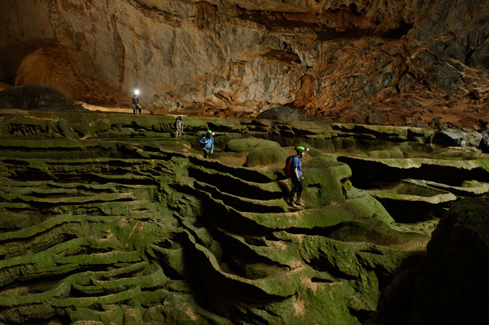
8 - Like a petrified waterfall, a cascade of fluted limestone, greened by algae, stops awestruck cavers in their tracks.


9 - Moss-slick boulders and a 30-foot drop test author Mark Jenkins at the forest-shrouded entrance to Hang Son Doong.
"Even though these caves are huge, they're practically invisible until you're right in front of them," Jenkins says.
Hunters have found caves by spotting winds gusting from underground openings.
 

10 - Hang Son Doong's airy chambers sprout life where light enters from above - a different world from the bare, cramped, pitch-black spaces familiar to most cavers. Ferns and other greenery colonize rimstone.

In the jungles directly beneath roof openings, explorers have seen monkeys, snakes, and birds.

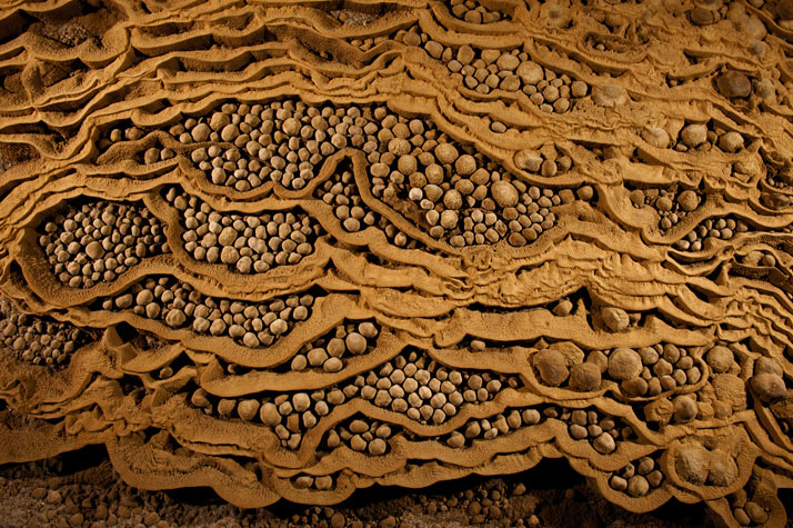
11 - Rare cave pearls fill dried-out terrace pools near the Garden of Edam in Hang Son Doong.
This unusually large collection of stone spheres formed drip by drip over the centuries as calcite crystals left behind by water layered themselves around grains of sand, enlarging over time.
 

12 - Navigating an algae-skinned maze, expedition organizers Deb and Howard Limbert lead the way across a sculpted cavescape in Hang Son Doong.

Ribs form as calcite-rich water overflows pools.


13 - Like a castle on a knoll, a rock formation shines beneath a skylight in Hang Son Doong. A storm had just filled the pool, signaling that exploring season was coming to an end.
 

14 - The trickiest challenge for the expedition team was to find a way over the Great Wall of Vietnam, an overhanging mass of flowstone that blocked the way deep inside Hang Son Doong.

Climbing specialists "Sweeny" Sewell and Howard Clarke here work on anchoring bolts to the slippery, porous rock to support the weight of climbers using ropes.

Once over the wall, the expedition team discovered a second entrance into the cave.
15 - Dubbed the Great Wall of Vietnam, a 200-foot cliff halted the advance of the first team to enter Hang Son Doong, in 2009. When explorers returned, Sewell drilled bolts for climbers to scale the obstacle with ropes.

A white streak below, to his right, marks how high water rises during the wet season.

16 - "It sounded like a roaring train," said "Sweeny" Sewell, describing the noise a second before a waterfall exploded into Hang Son Doong through the Watch Out for Dinosaurs doline, or sinkhole opening.
A rare dry-season downpour produced the thundering runoff. Were the cavers scared of drowning?
"Maybe if it were a smaller cave," said expedition leader Howard Limbert, "but not here."

17 - In the dry season, from November to April, a caver can safely explore Hang Ken, with its shallow pools. Come the monsoon, the underground river swells and floods the passages, making the cave impassable.
 

18 - Taking the only way in, a climber descends 225 feet by rope into Hang Loong Con. A survey party discovered the cave in 2010, hoping it would connect with the enormous Hang Son Doong.

A wall of boulders soon blocked the way, but a powerful draft indicated that a large cavern lay on the other side.
 

19 - Streams of light from the surface unveil stalagmites fat and thin on the floor of Hang Loong Con.
Cavers called the new find the Cactus Garden.